NOAA Guides Easier Hudson River Navigation

Real-time data on coastal conditions will support improved maritime navigation in New York.
Navigating New York waterways just got a bit easier. NOAA and the New York State Department of Environmental Conservation announced the establishment of the Hudson River Estuary Physical Oceanographic Real-time System (PORTS). The system delivers real-time oceanographic and meteorological observations that can improve maritime safety and inform coastal resource management in the region. Commercial mariners, recreational boaters, resource managers, and coastal planners can use the online tool to access real-time water level data from Sleepy Hollow to Troy, New York.
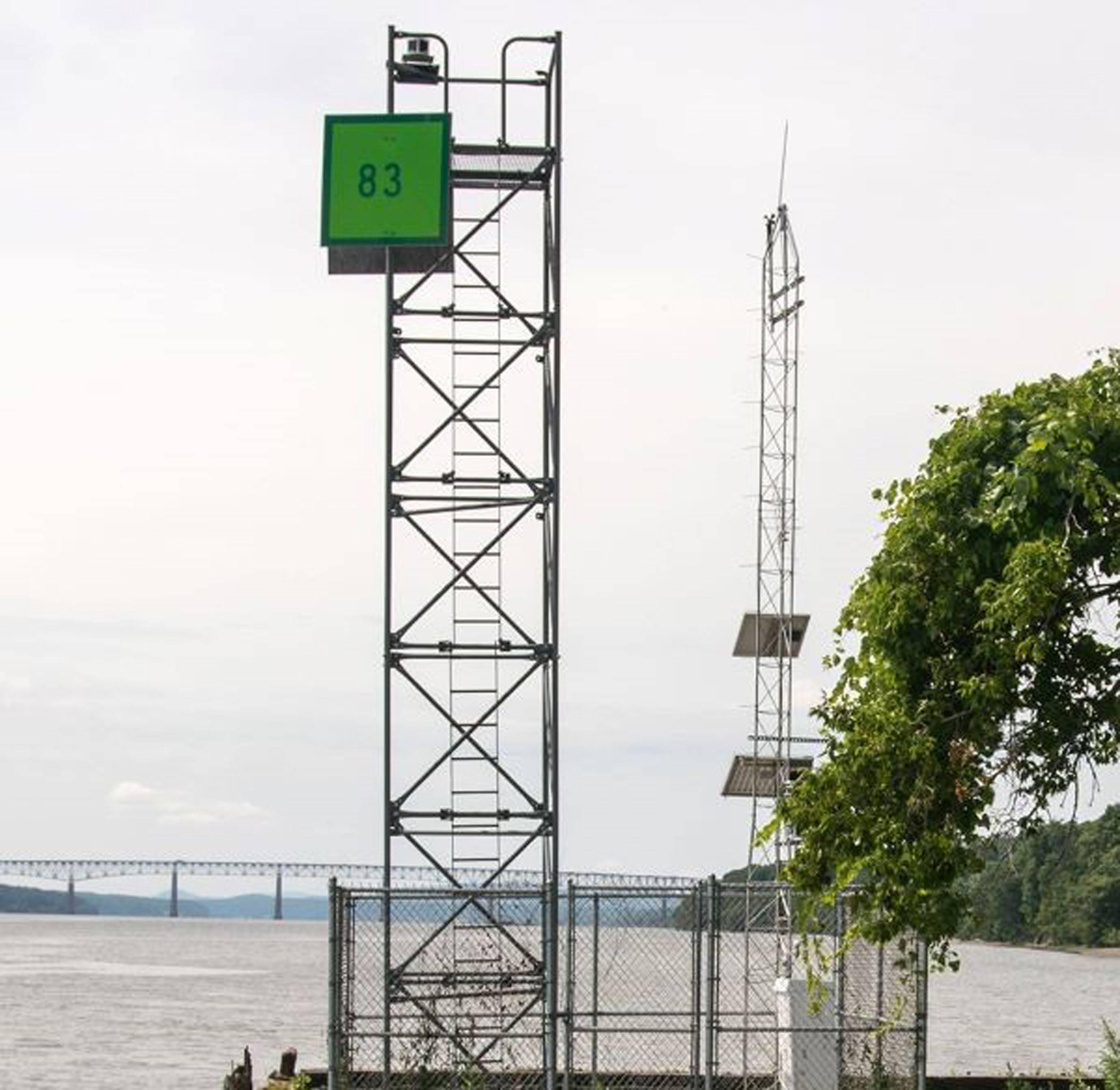
The Hudson River Estuary PORTS is the second system of its kind in New York — the first being situated 100 miles south that provides data for the New York-New Jersey Harbor PORTS. The new system currently consists of one water level station at Turkey Point, south of Saugerties, New York, and is part of the New York State Department of Environmental Conservation’s Hudson River National Estuarine Research Reserve. The system will fill critical geographic gaps in the state’s maritime data and expand coverage to include the tidally influenced portions of the Hudson River, north of the Mario M. Cuomo Bridge.
The Turkey Point station is equipped with pressure-based and microwave water level sensors, satellite transmitters, as well as rechargeable batteries and solar panels. The redundancy of the built-in sensors and power sources is designed to ensure the station operates in all weather conditions, and that NOAA’s critical real-time data continues to flow when it is most urgently needed by the maritime community. The station is also equipped with an anemometer that measures wind speed, pressure, and direction; sensors for air and water temperature, relative humidity, and conductivity; as well as a barometric pressure sensor to measure meteorological conditions.
A second water level station will be added to the system later this year to deliver data from the upper portion of the Hudson River at the Coxsackie State Boat Launch and Riverside Park.
Partners at the New York State Department of Environmental Conservation will maintain system sensors and provide sensor data and metadata to NOAA in accordance with National Ocean Service standards. NOAA will publish verified data on the Tides and Currents website. This collaborative effort will result in highly precise oceanographic and meteorological data delivered through NOAA web products in near real time.
With the Hudson River Estuary PORTS, NOAA now operates 39 real-time systems across the nation. NOAA PORTS is a partnership program with local port authorities, pilot associations, the U.S. Coast Guard, the U.S. Navy, the U.S. Army Corps of Engineers, academia, and other stakeholders across the nation. Its systems support safe and cost-efficient navigation by providing ship masters, pilots, and other users with accurate real-time information required for safe vessel loading and transit, and to avoid groundings and collisions. These systems also improve hazardous spill response and enhance recreational activities.
Climate, weather, and water affect all life on our ocean planet. NOAA’s mission is to understand and predict our changing environment, from the deep sea to outer space, and to manage and conserve America’s coastal and marine resources. See how NOAA science, services, and stewardship benefit your community: Visit noaa.gov for our latest news and features, and join us on social media.