

AMI Marine Receives Panama Approvals for SMIDS Pro GNSS Speed Log

AMI Marine has passed approvals for their ACP (Panama Canal Authority) Non‑Portable Piloting Aid (NPU) option for the SMIDS Pro GNSS Speed Log system.These new approvals further strengthen the SMIDS Pro portfolio and confirm its suitability for vessels requiring reliable, compliant, and future‑ready speed and distance measurement solutions.This next‑generation system introduces new features, including:High‑precision GNSS‑based speed and distance measurement, and headingEnhanced operational reliability and performance…
ChartWorld, Raymarine Commercial Unify Under Single Brand

Teledyne Technologies Incorporated announced the unification of ChartWorld and Raymarine Commercial under a single commercial navigation brand, Raymarine Commercial. As part of the unification, ChartWorld’s commercial navigation solutions and services will transition fully into the Raymarine Commercial brand, further strengthening Teledyne’s position as a global leader in maritime navigation solutions and demonstrating the successful integration of acquired businesses into its core operations.The combination brings ChartWorld’s established digital navigation…
Lloyd’s Register Live Trials Orca AI's Navigation Technology Onboard Vessel

Lloyd’s Register (LR) has tested Orca AI's AI-powered navigation system during a live vessel trial.The assessment focused on how AI-based computer vision can support human decision-making in real operating conditions, particularly in complex navigation scenarios such as congested waters and reduced visibility.The trial was conducted on a feeder containership during a five-day voyage through some of the Mediterranean’s busiest shipping lanes, from the port of Gioia Tauro in Italy to Marsaxlokk, Malta.
Study From Orca AI, NorthStandard Highlights Role of of AI on Navigational Safety

A large-scale operational study conducted jointly by Orca AI and leading P&I club NorthStandard marks the first time an AI navigation provider and marine insurer have combined large-scale operational data to quantify the real-world impact of AI on navigational safety.Based on data from a globally operating cohort of 139 vessels, the study found that deployment of Orca AI’s platform resulted in a 52% reduction in high-severity close encounters over 12 months, with an initial 22% reduction achieved within the first six months.The study examined more than 10.8 million nautical miles of voyages…
Anschütz SYNAPSIS Nav Tech for New Multipurpose Vessel

Anschütz has been awarded the contract to supply Integrated Navigation and Bridge Systems (INBS) for three multipurpose vessels being built for the German Waterways and Shipping Administration (WSV) at the Abeking & Rasmussen shipyard. The first of these, the Scharhörn, has successfully completed a series of sea trials and is nearing delivery.Anschütz equips these ships with SYNAPSIS INBS technology. SYNAPSIS offers a high level of integration and automation, providing the crew with clear and precise information about the maritime environment to support safe navigation…
STAPEM Ops for Sonardyne’s Precise Positioning System
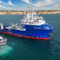
France-based STAPEM Group has chosen Sonardyne’s Ranger 2 Ultra-Short BaseLine (USBL) technology as the permanent solution for one of its flagship offshore support vessels, the STAPEM Boreale.Operating in one of STAPEM Group’s key regions, Angola, the vessel is now equipped with a Ranger 2 GyroUSBL 7000 system, an all-in-one, high-performance USBL system for precise positioning performance, previously used on a hire basis.Ranger 2 GyroUSBL 7000 is optimized for ultra-deepwater operations and, like all Ranger 2 GyroUSBL systems, includes a single, pre-calibrated transceiver head.
Steering Failure Caused Vessel to Make Contact with Navigational Aid
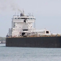
A steering system failure led to a bulk carrier’s contact with a navigational aid in the St. Marys River near Sault Ste. Marie, Michigan, according to the National Transportation Safety Board.The bulk carrier American Mariner struck the Munuscong Channel Junction Light on March 28, 2024, as it was transiting upbound in the St. Marys River. The Munuscong Channel Junction Light is comprised of a navigational light and signal mounted on a concrete, fixed structure.After the contact the vessel began taking on water but was stabilized using pumps.
Anschütz Rolls Out Navigation and Command System for Autonomous Navy Ops

German navigation specialist Anschütz has developed a navigation and command system for autonomous and unmanned maritime operations. The approval-ready system has undergone extensive testing in autonomous operation and is currently being prepared for use in prototypes, according to the company.The autonomous navigation and command system from Anschütz provides navies with a sustainable capability and safety enhancement for unmanned systems. It ensures autonomous navigation and control and operation of unmanned platforms…
Ireland Elected to the Council of IALA

Ireland has been elected to the Council of IALA, the International Organisation for Marine Aids to Navigation. IALA was founded in 1957 and has recently transitioned into an inter-governmental organization. The Irish Government ratified the IALA Convention in May 2023, marking a milestone in Ireland’s commitment to international co-operation in maritime safety and to shaping the future of global navigation.The election of Ireland to the new IALA Council took place during the inter-governmental organization's inaugural General Assembly in Singapore on February 20, 2025.
Misinterpretation of Aids to Navigation Contributed to Vessel Grounding

Following the grounding of one of its pilot transfer launches in Port Phillip Heads, Australia, a Port of Melbourne pilotage services provider has developed additional operational guidance on the use of launch equipment and crew resources.On the evening of October 5, 2023, the pilot launch Corsair was returning through the entrance of Port Phillip after collecting a pilot from an outbound container ship, when it ran aground on Point Lonsdale Reef travelling at about 24 knots.The coxswain…
NOAA Guides Easier Hudson River Navigation
Real-time data on coastal conditions will support improved maritime navigation in New York.Navigating New York waterways just got a bit easier. NOAA and the New York State Department of Environmental Conservation announced the establishment of the Hudson River Estuary Physical Oceanographic Real-time System (PORTS). The system delivers real-time oceanographic and meteorological observations that can improve maritime safety and inform coastal resource management in the region.
IALA Becomes Intergovernmental Organization

After more than 10 years of work and four diplomatic conferences, The International Association of Marine Aids to Navigation and Lighthouse Authorities (IALA) has officially changed from a non-governmental organization (NGO) to an Intergovernmental Organization (IGO).The transition to an Intergovernmental Organization will place IALA in a much stronger position to develop and harmonize Marine Aids to Navigation, as governments will be directly involved in the work. All major decisions will be made by representatives of their governments…
NAVTOR Releases NavFleet Emissions Simulator

NAVTOR, an e-Navigation and performance technology provider to the maritime industry, said Wednesday it was aiming to simplify CII compliance with the latest release of its NavFleet ship operations platform. Featuring an advanced Emissions Simulator, designed to help shipping companies predict and optimize environmental impact and performance across entire fleets, NavFleet 1.8 delivers operational insights built on high-quality, dual-validated data, the company said.The result…
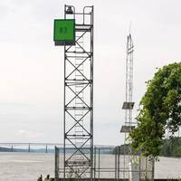
Major Port Hedland Navigation Project Completed
The Australian Maritime Safety Authority (AMSA) has completed a major A$15.5 million two-year project to repair and rejuvenate essential aids to navigation (AtoNs) off the coast of Port Hedland, Western Australia.AMSA commissioned the works following Severe Tropical Cyclone Veronica in 2019, which caused significant damage to electrical equipment, access ladders, platforms, day markers and fenders.AMSA has replaced the top of 13 AtoNs, installed new platforms and above water pile sections…
SevenCs Releases ORCA Pilot X Software
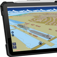
SevenCs, part of the ChartWorld Group, announced the release of ORCA Pilot X software. Originally designed as a primary navigation aid for Pilots, ORCA Pilot X is a tool for professional navigators. ORCA Pilot X is being offered as a free download on the Apple AppStore for iOS tablets.SevenCs has a long tradition of developing bespoke navigation applications for pilots around the world. Following the feedback and input from many users, SevenCs began the development of ORCA Pilot X as the natural evolution from ORCA Pilot G2.Ralf Lehnert…
MOL Intros AR Navigation System
Japanese transportation major Mitsui O.S.K. Lines (MOL) announced that, along with Furuno Electric, it made a joint presentation of their advanced augmented reality (AR)-based Navigation System.The presentation introduced the background behind the technology and development of the system, as well as MOL’s efforts to "forge ahead to become the world leader in safe operation."The AR Navigation System provides visual support to crew-members during their watch-keeping and ship operations by using AR technology to superimpose real-time video imagery and voyage information.Large tankers, which have a deep draft (The vertical distance between the bottom of the hull and the waterline), require very careful ship operations in waters such as the Strait of Malacca, a highly congested shipping lane.
New GNS Voyager Planning Station Ready
The maritime services group Global Navigation Solutions (GNS) has announced a further enhancement to its Voyager Planning Station (VPS), with the addition of tools to manage compliance with special environmental requirements under International Maritime Organization (IMO) MARPOL regulations.The specialist providers of maritime navigation information, solutions and support to the global shipping industry said in a press release that the upgrade comes as part of the release of Voyager 7.3.4, making it easier for users to manage MARPOL compliance with designated Special Areas, Emission Control Areas and Particularly Sensitive Sea Areas."The new feature gives users the ability to view up to date areas under MARPOL as an overlay on either a map or an ENC from within Voyager…
JIN Honors NYK for New Navigation Tool
Japanese shipping company Nippon Yusen (NYK) has been recognized with a special award from the Japan Institute of Navigation (JIN) for improving onboard operation through use of J-Marine NeCST, a ship navigation support tool that was jointly developed by NYK, MTI Co. Ltd., and Japan Radio Co. Ltd. (JRC).J-Marine NeCST (NeCST is pronounced “Next”) allows users to easily plan routes using the handwriting function of the electronic navigational chart, in addition to managing and sharing operational data using integrated information such as meteorological and hydrographical forecasts.An awards ceremony was held on July 12, 2019, and attended by Tomoyuki Koyama…
IMO Workshop on e-Navigation in AsiaPac
The implementation of e-navigation - the user-friendly collection, harmonization and display of essential maritime information - will contribute to enhanced maritime safety and security and support efficient shipping while protecting the marine environment, says International Maritime Organization (IMO).Various e-navigation solutions are being developed, taking into account IMO guidance and regulations.The SMART-Navigation Project, organized and funded by the Ministry of Oceans and Fisheries, Republic of Korea, was presented during an IMO regional workshop on e-navigation for the Asia-Pacific region, held in Busan, Republic of Korea…
Furuno's Berthing Aid System Receives ClassNK's Endorsement
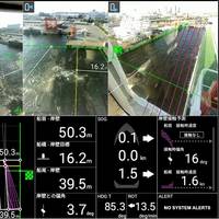
Japanese classification society ClassNK has granted its Innovation Endorsement for Products & Solutions to a Berthing Aid System developed by Furuno.Furuno's Berthing Aid System displays the distance and angle between the ship and the quay to assist in berthing operations.The Berthing Aid System uses LiDAR to calculate the relative distance and angle between the quay and hull, and displays superimposed images for situational awareness. The system aims to improve safety during berthing by measuring and visualizing the positional relation between the quay and ship…
ChartCo Opens New Office in Greece
ChartCo, the global provider of digital navigation and compliance solutions, has expanded its global network of offices to Piraeus, Greece to help provide dedicated support for customers in this region for the shipping industries.The global leader in digital navigation services is currently supplying and supporting customers in commercial shipping, offshore, cruising and superyachts all around the world and has a prominent presence of offices in the UK, Europe and Southeast Asia.Over the past decade, ChartCo has established its footprint within the shipping industry in Greece and Cyprus, and now serves more than 100 companies and over 1…
USCG: WAMS Study for Les Cheneaux Islands
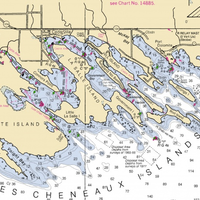
The Coast Guard Sector Sault Sainte Marie is seeking input for a Waterways Analysis and Management System (WAMS) study of the Les Cheneaux Islands.The WAMS study will review the short range Aids to Navigation system that covers the waters surrounding the Les Cheneaux Islands, including: Cedarville East Channel, Les Cheneaux Islands Middle Entrance, Les Cheneaux Islands West Entrance, Mackinac Bay Passage, Muscallonge Bay, and Cedarville West Channel.The purpose of the WAMS is to ensure that surrounding waters of the Les Cheneaux Islands are the safest…
Sensor Systems Improve Marine Navigation Near US Naval Bases
Maritime navigational safety near two U.S. Navy installations in Kings Bay, Ga., and Portsmouth, N.H. has been improved thanks to new Physical Oceanographic Real-Time Systems, also known as PORTS, installed by NOAA and the U.S. Navy. They are the first new PORTS in two years, and the 34th and 35th in the nationwide network.The system near Naval Submarine Base Kings Bay, the East Coast home to America’s Ohio-class submarines, is an integrated series of sensors which will provide critical real-time information on oceanographic and meteorological conditions.


