
NOAA
The National Oceanic and Atmospheric Administration (NOAA) is a scientific agency within the United States Department of Commerce. It focuses on the conditions of the oceans, major waterways, and the atmosphere. Established in 1970, NOAA plays a key role in understanding and managing the environment and natural resources.
Here are some of NOAA's primary functions and areas of responsibility:
Weather Forecasting and Warnings: NOAA's National Weather Service (NWS) provides weather forecasts, warnings for severe weather, and other weather-related information to ensure the safety of the public and the protection of property.
Climate Research: NOAA conducts research on climate trends and changes. This includes monitoring atmospheric conditions, studying long-term climate patterns, and providing data that can be used to make predictions about future climate conditions.
Marine and Coastal Resource Management: NOAA manages marine fisheries, protects marine habitats, and works to sustain populations of various marine species. The organization is involved in the conservation and management of marine and coastal ecosystems.
Ocean Exploration: NOAA is involved in exploring the world's oceans, mapping the seafloor, and discovering marine life and underwater geological formations. This contributes to our understanding of oceanic processes and marine biodiversity.
Environmental Monitoring: NOAA operates a network of satellites and observation systems to monitor environmental conditions on Earth. This network provides critical data for weather forecasting, climate monitoring, and the study of natural phenomena.
Research and Education: NOAA conducts and supports research to enhance our understanding of environmental issues. It also offers educational programs and resources to promote environmental literacy and encourage careers in science and technology.
Emergency Response: NOAA provides essential data and services during natural disasters and emergencies such as hurricanes, tsunamis, and oil spills, offering guidance and support for response and recovery efforts.
NOAA's work is critical for disaster preparedness, environmental conservation, and scientific research, influencing a wide range of sectors including agriculture, transportation, commerce, and public health.
NOAA's headquarters is located in Silver Spring, Maryland, but it has numerous laboratories, research facilities, and operational centers across the United States and its territories. NOAA partners with other government agencies, international organizations, and private sector entities to achieve its mission and objectives.
government
- Phone: 206.553.5749
- Web: www.noaa.gov
- Fax: 206.553.4340
Locations
NOAA News
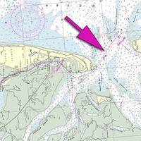
NOAA Updates New York Harbor Charts Post-Sandy
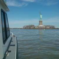
Ships, barges, ferries, and recreational boats in the busy New York Harbor will be able to navigate more safely thanks to an updated version of the harbor’s nautical chart recently issued by NOAA that includes data gathered in the navigational response to the damage caused by Sandy in October 2012. The latest edition of Chart 12334 – New York Harbor includes new depth measurements and shoreline depictions.
Arctic Marine Survey Work: NOAA & Coastguard Join Hands
With 3.4 million square nautical miles of U.S. waters to survey and chart, Coast Survey is up against some big challenges in keeping nautical charts current, consequently NOAA joins hands with the US Coast Guard to provide the best possible safety service to shipping. With the Alaskan coast comprising 57% of the U.S. navigationally significant waters, a multi-agency partnership for hydro survey data is necessary for maritime safety. Since 2008, NOAA has been working with the U.S.
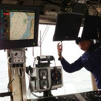
NOAA Unveils New Electronic Chart Online Viewer
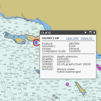
For more than ten years, since NOAA introduced its electronic navigational charts, you have needed to purchase a specialized chart display system to view the NOAA ENC® as a seamless chart database. Starting today, you don’t need a system to view the ENC depictions; you can use Coast Survey’s new web-based viewer called NOAA ENC® Online . (IMMEDIATE CAVEAT: You still need a specialized display system to use the multi-layered functional data that make ENCs so valuable.
Tell NOAA If You Think the IWR Still Needs the 'Magenta Route'
If you are a recreational boater, fisherman, or another member of the maritime community, NOAA's Office of Coast Survey wants to pick your brain about the "magenta line," which historically depicted the recommended route for the Intracoastal Waterway Route (IWR) on NOAA nautical charts. A recent Federal Register Notice outlines NOAA's options for improving the accuracy of the magenta line, which is presently being removed from new editions of nautical charts.
NOAA Reports Sustained Seafood Levels
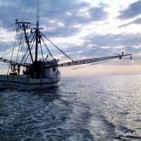
An annual report released by NOAA stated U.S. commercial fishermen landed 9.6 billion pounds of fish and shellfish in 2012, valued at $5.1 billion, according to Fisheries of the United States 2012. The value and pounds of fish and shellfish caught remain higher than the average for the previous ten years of 9.2 billion pounds and $4.1 billion, although this represents a small decrease from the high level of landings and value in 2011.
Death Knell for NOAA Traditional Paper Nautical Charts
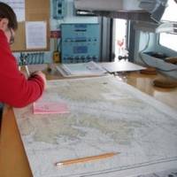
NOAA’s Office of Coast Survey has announced major changes ahead for mariners and others who use nautical charts. Starting April 13, 2014, the federal government will no longer print traditional lithographic (paper) nautical charts . NOAA will continue to provide other forms of nautical charts, including Print-on-Demand paper charts as well as electronic and digital formats. Since 1862, those lithographic…
Harris Helps Prepare NOAA GOES-R Extreme Weather Satellite
International communications and information technology company, Harris Corporation, has delivered a system that will help prepare National Oceanic and Atmospheric…
NOAA Identifies Lurking Environmental Threats

A new NOAA report that examines national oil pollution threat from shipwrecks has been presented to the U.S. Coast Guard. With as many as 20,000 recorded shipwrecks in NOAA’s database, the May 2013 report finds that just 36 sunken vessels scattered across the U.S. seafloor could pose an oil pollution threat to the nation’s coastal marine resources. Of those, 17 were recommended for further assessment and potential removal of both fuel oil and oil cargo.
NOAA Awards $967,000 to 11 Marine Debris Removal Projects
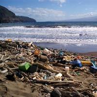
NOAA’s Marine Debris Program provided $967,000 through its Restoration Center to support locally driven, community-based marine debris prevention and removal projects. Eleven groups across the country received funding to remove derelict fishing nets, litter, lumber, tires and other harmful marine debris from shorelines and coastal waters. “Marine debris plagues coastlines all over the country, and these communities have the expertise and motivation to address it…
NOAA Updates Cobscook Bay Area Chart
Northern Maine vessels will be able to navigate more safely around the dangerous Cobscook Bay thanks to an updated version of the area's nautical chart issued by NOAA.
NOAA Finds Lost 19th Century U.S. Coast Survey Steamer
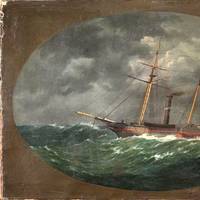
More than 153 years after it was lost in a violent collision at sea, government and university maritime archaeologists have identified the wreck of the ship Robert J. Walker, a steamer that served in the U.S. Coast Survey, a predecessor agency of NOAA. The Walker, while now largely forgotten, served a vital role as a survey ship, charting the Gulf Coast ‒ including Mobile Bay and the Florida Keys ‒ in the decade before the Civil War.
NOAA Seeks Hydrographic Panel Members
NOAA is seeking qualified candidates to apply for up to five voting member vacancies to serve on its Hydrographic Services Review Panel (HSRP) as of January 1, 2014.
NOAA Proposal Aims to Extend Reduced Whale Ship Strikes
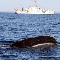
NOAA Fisheries is seeking comments on its proposal to make permanent the rules it implemented five years ago to reduce the number of collisions between ships and North Atlantic right whales. Right whales are among the most endangered species in the world, and are highly vulnerable to ship collisions. The rules, part of NOAA's long-standing efforts to recover right whales, are currently scheduled to expire in December 2013.
Begich, Wicker, Schatz Introduce NOAA Corps Amendments Act

U.S. Senators Mark Begich, Roger Wicker (R-MS) and Brian Schatz (D-HI) introduced legislation to strengthen the National Oceanic and Atmospheric Administration’s (NOAA) Commissioned Officer Corps as a national asset and improve its ability to recruit and retain talented candidates like other uniformed services. Begich is chairman of the Senate Subcommittee on Oceans, Atmosphere, Fisheries and Coast Guard. Wicker and Schatz serve on the subcommittee as well.
NOAA Report Examines Shipwreck Oil Pollution Threat
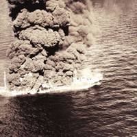
NOAA presented to the U.S. Coast Guard today a new report that finds that 36 sunken vessels scattered across the U.S. seafloor could pose an oil pollution threat to the nation’s coastal marine resources. Of those, 17 were recommended for further assessment and potential removal of both fuel oil and oil cargo. The sunken vessels are a legacy of more than a century of U.S. commerce and warfare. They include a barge lost in rough seas in 1936…
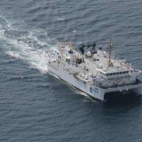
New NOAA ROV On Ocean Trials
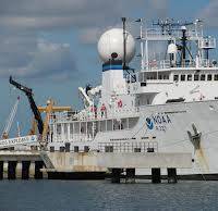
The 6,000-meter-rated remotely operated vehicle (ROV) system will be tested from 'Okeanos Explorer' in the 2013 field season. Dave Lovalvo, project manager for the NOAA Office of Ocean Exploration and Research’s Deep Submergence Group and his team has built and will be testing the ROV during the 2013 field season. The vehicle will be operated from the NOAA Ship Okeanos Explorer, America's only U.S. government ship that is dedicated to the sole purpose of exploring the world’s oceans.
NOAA Considers Effects of Arctic Oil and Gas Activities
NOAA is seeking comments on a supplemental draft environmental impact statement (EIS) for oil and gas activities in the Arctic Ocean. The draft, developed in collaboration with the Department of the Interior's Bureau of Ocean Energy Management (BOEM), includes analysis on how a broader range of potential offshore oil and gas activities could affect the environment, with a specific focus on marine mammals…
NOAA Ship's Annual Shakedown Cruise
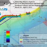
The 'Okeanos Explorer' is conducting mapping operation in the Western North Atlantic as part of the annual ship shakedown. Multibeam and singlebeam mapping operations are being conducted 24/7 between Rhode Island and the U.S.-Canadian territorial boundary, while sub-bottom profile mapping is being conducted each day between the hours of 1000 and 1800 throughout the March 18, 2013, to April 5, 2013 cruise.
New Polar-Orbit Satellite Under NOAA Control
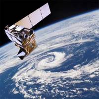
These satellites are critical for advanced warning of severe weather including tornado outbreaks, heavy snowfall, hurricanes, heat waves, floods, & wildfires. Data from the Suomi National Polar-orbiting Partnership (Suomi NPP) satellite will continue to strengthen NOAA’s ability to predict severe weather days in advance. Suomi NPP data are also used to generate dozens of environmental data products, including measurements of clouds, vegetation, ocean color, and land and sea surface temperatures.
Krill Systems Completes NOAA Contract
Krill Systems Inc. have installed their Vessel Fuel Measurement and Monitoring Systems (VFMMS) in 6 NOAA Fisheries survey vessels. Installations on NOAA Ship Bell M. Shimada, NOAA Ship Oscar Dyson and NOAA Ship Ferdinand R. Hassler represent the final fittings of a multiple vessel NOAA contract awarded in a competitive bid, on an unrestricted basis, to Krill Systems to implement VFMMS (Vessel Fuel Measuring and Management Systems) within their fleet.