

NOAA
The National Oceanic and Atmospheric Administration (NOAA) is a scientific agency within the United States Department of Commerce. It focuses on the conditions of the oceans, major waterways, and the atmosphere. Established in 1970, NOAA plays a key role in understanding and managing the environment and natural resources.
Here are some of NOAA's primary functions and areas of responsibility:
Weather Forecasting and Warnings: NOAA's National Weather Service (NWS) provides weather forecasts, warnings for severe weather, and other weather-related information to ensure the safety of the public and the protection of property.
Climate Research: NOAA conducts research on climate trends and changes. This includes monitoring atmospheric conditions, studying long-term climate patterns, and providing data that can be used to make predictions about future climate conditions.
Marine and Coastal Resource Management: NOAA manages marine fisheries, protects marine habitats, and works to sustain populations of various marine species. The organization is involved in the conservation and management of marine and coastal ecosystems.
Ocean Exploration: NOAA is involved in exploring the world's oceans, mapping the seafloor, and discovering marine life and underwater geological formations. This contributes to our understanding of oceanic processes and marine biodiversity.
Environmental Monitoring: NOAA operates a network of satellites and observation systems to monitor environmental conditions on Earth. This network provides critical data for weather forecasting, climate monitoring, and the study of natural phenomena.
Research and Education: NOAA conducts and supports research to enhance our understanding of environmental issues. It also offers educational programs and resources to promote environmental literacy and encourage careers in science and technology.
Emergency Response: NOAA provides essential data and services during natural disasters and emergencies such as hurricanes, tsunamis, and oil spills, offering guidance and support for response and recovery efforts.
NOAA's work is critical for disaster preparedness, environmental conservation, and scientific research, influencing a wide range of sectors including agriculture, transportation, commerce, and public health.
NOAA's headquarters is located in Silver Spring, Maryland, but it has numerous laboratories, research facilities, and operational centers across the United States and its territories. NOAA partners with other government agencies, international organizations, and private sector entities to achieve its mission and objectives.
government
- Phone: 206.553.5749
- Web: www.noaa.gov
- Fax: 206.553.4340
Locations
NOAA News
NOAA to Boost Arctic Nautical Charting
NOAA plans increased 2015 Arctic nautical charting operations, coordinating with U.S. As commercial shipping traffic increases in the Arctic, NOAA informs it is taking steps to update nautical charts in the region. NOAA’s Office of Coast Survey will use data collected by two of its own ships, Rainier and Fairweather, as well as the U.S. Coast Guard cutter Healy and a private sector hydrographic contractor to cover nearly 12…
Vice Adm. Brown Confirmed as NOAA Deputy Administrator

Retired Coast Guard Vice Adm. Manson Brown was appointed by President Obama and confirmed by a voice vote of the U.S. Senate to serve as assistant secretary of commerce for environmental observation and prediction and deputy administrator for NOAA. Brown joins NOAA after 36 years of service in the U.S. Coast Guard. As deputy administrator, Brown will play a major role driving the Obama administration and NOAA priorities for weather and water services…
New Lineup for NOAA Hydrographic Services Panel
NOAA administrator Kathryn Sullivan, Ph.D., has appointed six members to the Hydrographic Services Review Panel, a federal advisory committee that gives NOAA independent advice for improving a range of services and products that support navigation and coastal resilience. Capt. “Providing coastal communities, boaters, and the commercial maritime industry with timely, reliable, accurate, and authoritative information is essential as we strive to keep commerce flowing through our nation’s ports…
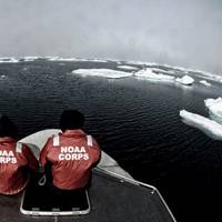
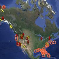
NOAA Satellites Help Rescue 240 People Last Year
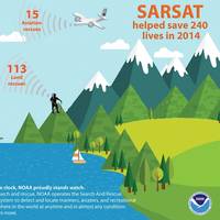
Last year, 240 people were saved from potentially life-threatening situations throughout the United States and its surrounding waters with help from NOAA’s fleet of weather satellites. In addition to their role in weather forecasting, NOAA’s polar-orbiting and geostationary satellites can detect distress signals from emergency beacons carried by downed pilots, shipwrecked boaters and stranded hikers.
USCG, NOAA Ink Fleet Plan Agreement

Senior leaders from the U.S. Coast Guard (USCG) and the National Oceanic and Atmospheric Administration (NOAA) signed a Fleet Plan and Officer Exchange memorandum of understanding Wednesday at a ceremony at U.S. Coast Guard Headquarters. Coast Guard Vice Adm. Charles Michel, deputy commandant for operations, and NOAA Vice Adm. Michael Devany, deputy under secretary for operations, were the signing officials for the joint letter of promulgation.
NOAA Orders Newbuild Navigation Response Boats

NOAA today announced that Lake Assault Boats of Superior, Wisconsin, will build two small vessels for the Office of Coast Survey's navigation response program, part of a plan to eventually replace all six of the program's small survey boats. The combined cost of both 28-foot vessels is $538,200. "All of the navigation response team survey boats are nearing or have exceeded their designed service life," said Russ Proctor, division chief of Coast Survey's Navigation Services Division.
NOAA Expands Thunder Bay National Marine Sanctuary
NOAA today released a final rule and environmental impact statement expanding the boundaries of Thunder Bay National Marine Sanctuary in Lake Huron from 448 square miles to 4,300 square miles.
US Warships Evacuate NOAA Pacific Island Researchers
Sailors and Marines from the Makin Island Amphibious Ready Group (ARG) and 11th Marine Expeditionary Unit (MEU) have conducted an emergent recovery of 11 researchers…
TerraSond Gets 5-Year NOAA Survey Contract
TerraSond says it has been selected by the National Oceanic and Atmospheric Administration (NOAA) to provide hydrographic surveying services anywhere in the U.S under a new five-year contract.
NOAA Reports 2011 Ocean, Great Lakes Economy Data
NOAA’s newest output includes a feature on economics. The National Ocean Watch site features facts, charts, story maps and videos. It turns out that our maritime economy – commercial, recreational and everything in between – really matters. In 2011, the U.S. Ocean and Great Lakes economy produced $282 billion in goods and services and employed 2.2 percent of the nation’s workers—that’s more than twice the percentage of workers in the U.S. agriculture industry.
NOAA Data Reveals Weight of Ocean and Great Lakes Economy
In 2011, the U.S. ocean and Great Lakes economy produced $282 billion in goods and services and employed 2.2 percent of the nation’s workers—that’s more than twice the percentage of workers in the U.S. agriculture industry. This fact and many others are featured in a 2011 data summary from Economics: National Ocean Watch (ENOW), a product of the National Oceanic and Atmospheric Administration (NOAA) Coastal Services Center.
NOAA Certifies 11Printers for Paper Charts

Mariners and the boating public have a wider choice of options and special services when they purchase NOAA paper nautical charts, thanks to NOAA's expanded "print-on-demand" chart production and distribution system. Coast Survey has certified eleven chart printing agents who have the flexibility to offer different color palettes, various papers, a cleaner margin, and a range of services. Under the program…
NOAA Offers a New Way to See Currents
A new NOAA National Ocean Service website will provide mariners near real-time coastal ocean surface current observations and tidal current predictions in coastal waters using high frequency (HF) radar, making marine navigation safer for mariners and commercial shippers. The web-based observations are now available for the Chesapeake and San Francisco Bays in areas vital for marine navigation, with additional locations to follow.
NOAA Begins Hydrographic Survey Season
New data will update nautical charts around the country. As sure as spring arrives, NOAA vessels and independent contractors are hitting the seas for the nation's 180th hydrographic surveying season, collecting data for over two thousand square nautical miles in high-traffic U.S. coastal waters. "Nautical charts are the foundation for the nation's maritime economy, and NOAA hydrographers spend months at sea…
NOAA Certifies More Printing Agents
The availability of paper "print-on-demand" nautical charts continues to expand, as NOAA's Office of Coast Survey has added three more printing companies to its roster of certified agents for paper charts. "The most recent printers to join the NOAA paper chart program represent the enduring connections between maritime tradition and progress," said Capt. Shep Smith, chief of Coast Survey's Marine Chart Division.
Three NOAA scientists honored by White House
The White House yesterday awarded three NOAA scientists with Presidential Early Career Awards for Scientists and Engineers. The award is the highest honor given…
NOAA Nautical Charts Now Permanently Free

After a three-month trial period, PDF versions of NOAA nautical charts will become a permanent product, free to the public. The free PDFs, which are digital images of traditional nautical charts, are especially valued by recreational boaters who use them to plan sailing routes and fishing trips. The free PDF charts are part of a suite of new and enhanced navigational products designed to make NOAA’s data more accessible to the general public.
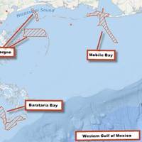
NOAA Creates Dynamic Whale Protection Area
The NOAA Fisheries Service has established a Dynamic Management Area near Savannah, Ga. to protect an aggregation of three whales sighted on January 23. Mariners…
NOAA Satellites Helped Save 253 People in 2013
The same NOAA satellites that helped forecasters predict severe weather, such as the Moore, Okla., tornado last May and November’s deadly Midwest tornado outbreak, also played a key role in rescuing 253 people from potentially life-threatening scenarios throughout the United States and its surrounding waters last year. A combination of NOAA polar-orbiting and geostationary satellites detected distress signals from emergency beacons carried by downed pilots…
No Fear, NOAA Paper Charts Still Near

The announcement that the federal government will stop bulk lithographic printing of nautical charts brought some understandable angst, however NOAA say they may be changing the chart production process but they will NOT stop the production of paper charts. The Agency explain they are working with private companies to make them better: printed in brighter colors and available for fast delivery to the door. Most importantly, they are up-to-date to the moment ordered.