Tropical Storm Cindy Rolls in on US Gulf Coast
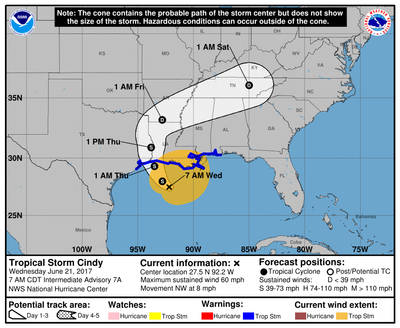
Cindy was located about 165 miles (265 km) south of Morgan City, Louisiana, early on Wednesday with maximum sustained winds of 60 miles (95 km) per hour, the NHC said.
The storm was moving northwest at nearly 8 miles (13 km) per hour, and forecasters said they expected this motion to continue until it hits the coast.
Cindy was projected to produce 6 to 9 inches (15-23 cm) of rain that could reach up to 12 inches in parts of Louisiana, Mississippi, Alabama and Florida, and cause "life-threatening flash flooding," the NHC said.
"It's a little stronger than it was yesterday, but the overall track is looking to be the same," said Stephen Strum, vice president of extended forecast services at Weather Decision Technologies in Tulsa, Oklahoma.
Rain will cause the biggest impact and fall most heavily from New Orleans to the Florida Panhandle, Strum added.
After the storm moves inland, it will track into the Tennessee Valley so that flooding concerns will continue through the weekend.
Heavy rains and wind could disrupt oil supplies at the massive refining and production centers along the U.S. Gulf Coast, which could drive up prices for consumers.
The Gulf of Mexico is home to about 17 percent of U.S. crude and 5 percent of dry natural gas output, according to the U.S. Energy Information Administration. More than 45 percent of the nation's refining capacity is along that coast, also home to 51 percent of total U.S. gas processing capability.
The Louisiana Offshore Oil Port, the largest privately owned crude storage terminal in the United States, suspended vessel offloading operations ahead of the storm but said Tuesday it expected no interruptions to deliveries from its hub in Clovelly, Louisiana.
Royal Dutch Shell said on Tuesday that it suspended some offshore well operations, but production was so far unaffected. Anadarko Petroleum Corp said it had evacuated non-essential staff from its Gulf of Mexico facilities.
The storm could cause a surge of up to 4 feet (1.2 meters) in isolated areas and possibly spawn tornados from southern Louisiana to the Florida Panhandle, the NHC said.
The Atlantic hurricane season runs from June 1 through Nov. 30. Most meteorologists forecast this year will be more active than normal.


