NOAA's National Hurricane Center: Michael Expected to Become a Hurricane
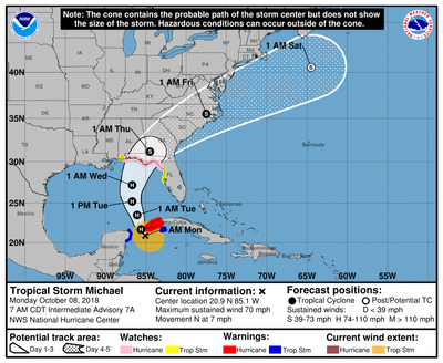
The National Hurricane Center has announced a Hurricane Warning is in effect for the Cuban province of Pinar del Rio. A Hurricane Watch is also in effect for the Alabama-Florida border to Suwannee River Florida.
A Tropical Storm Watch is in effect for Suwannee River to Anna Maria Island Florida, including Tampa Bay and for the Alabama-Florida border to the Mississippi-Alabama border
At 700 AM CDT (1200 UTC), the center of Tropical Storm Michael was located near latitude 20.9 North, longitude 85.1 West. Michael is moving toward the north near 7 mph (11 km/h). A northward motion at a slightly faster forward speed is expected through Tuesday night, followed by a northeastward motion on Wednesday and Thursday. On the forecast track, the center of Michael will move northward across the Yucatan Channel today, and then across the eastern Gulf of Mexico this evening through Wednesday. Michael is expected to move inland over the Florida Panhandle or Florida Big Bend area on Wednesday, and then move northeastward across the southeastern United States Wednesday night and Thursday.
Maximum sustained winds are near 70 mph (110 km/h) with higher gusts. Additional strengthening is forecast, and Michael is expected to become a hurricane later today. Michael is forecast to be near or at major hurricane strength when it reaches the northeastern Gulf of Mexico Tuesday night and Wednesday.
At present, tropical-storm-force winds extend outward up to 175 miles (280 km) from the center. The latest minimum central pressure reported by an Air Force reconnaissance aircraft is 982 mb (29.00 inches).


