NOAA Satellites Help Rescue 207 in 2011
In 2011, NOAA satellites were critical in the rescues of 207 people from life-threatening situations throughout the United States and its surrounding waters.
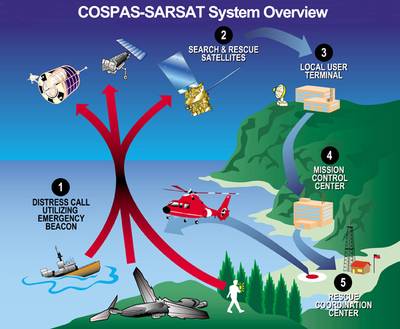
The satellites picked up distress signals from emergency beacons carried by downed pilots, shipwrecked boaters and stranded hikers, and relayed the information about their location to first responders on the ground. NOAA’s polar-orbiting and geostationary satellites are part of the international Search and Rescue Satellite Aided Tracking System, called COSPAS-SARSAT. This system uses a network of satellites to quickly detect and locate distress signals from emergency beacons onboard aircraft and boats, and from smaller, handheld personal locator beacons called PLBs.
Of the 207 saves last year, 122 people were rescued from the water, 14 from aviation incidents, and 71 in land situations where they used their PLBs. Other rescue highlights from the year include:
- Alaska had the most people rescued on land last year with 39, followed by Florida with 11, and California with 8.
- NOAA SARSAT played a critical role in the rescue of a group of student hikers from a grizzly bear attack in Alaska by directing first responders to the scene.
- In the pitch of night, two people were rescued from a life raft after their boat sank 140 miles off the coast of Marco Island, Fla.
- An elderly hiker was rescued 74 miles south of Colorado Springs, Colo., during a heavy snowstorm.
“With each rescue, this system performs the way it was intended — as a real, life-saving network,” said Chris O’Connors, program manager for NOAA SARSAT.
When a NOAA satellite finds the location of a distress signal, the information is relayed to the SARSAT Mission Control Center based at NOAA’s Satellite Operations Facility in Suitland, Md. From there, the information is quickly sent to a Rescue Coordination Center, operated by either the U.S. Air Force for land rescues or the U.S. Coast Guard for water rescues.
Since 1982, COSPAS-SARSAT has been credited with supporting more than 30,000 rescues worldwide, including more than 6,700 in the United States and its surrounding waters.
By law, owners of emergency beacons are required to register them with NOAA at: http://www.beaconregistration.noaa.gov. That registration information often helps provide better and faster assistance to people in distress. It may also provide information about the location of the emergency, how many people need assistance, what type of help may be needed and other ways to contact the owner. At the end of 2011 NOAA’s registration database contained over 329,000 registrations.
NOAA’s mission is to understand and predict changes in the Earth's environment, from the depths of the ocean to the surface of the sun, and to conserve and manage our coastal and marine resources. Join us on Facebook, Twitter and our other social media channels.


