

"No Find, No Fee" Search for MH370 to Commence

Nearly 12 years after Malaysia Airlines Flight MH370 vanished with 239 people on board, the mystery remains unresolved. Later this month, a new seabed search is scheduled to begin in the southern Indian Ocean, renewing hopes that long-awaited answers may finally emerge.The Boeing 777 disappeared on March 8, 2014, while en route from Kuala Lumpur to Beijing. The passengers included more than 150 Chinese nationals, around 50 Malaysians, and citizens from several other countries, including France, Australia, the United States, India, Canada and Ukraine.
Oil Loading in Venezuela Crawls After New US Interceptions

Tanker loading in Venezuela dwindled on Monday, with most ships moving oil cargoes only between domestic ports following U.S. action against two more ships and as state-run energy company PDVSA struggles to recover from a cyberattack, according to tracking data and sources.The U.S. Coast Guard this month seized a supertanker under sanctions carrying Venezuelan oil and tried to intercept two more Venezuela-related ships over the weekend, U.S. authorities said. One of them is an empty ship under U.S.
Venezuela Authorizes Two Unsanctioned VLCCs to Depart

Venezuela on Thursday authorized two very large crude carriers (VLCC) to set sail for China, according to two sources familiar with Venezuela's oil export operations, which would be only the second and third supertankers to depart the country since the U.S. seized a ship carrying Venezuelan oil last week.The U.S. has said it would not allow vessels under sanction to leave Venezuelan waters. The departing tankers, each carrying around 1.9 million barrels of Venezuelan Merey heavy crude according to internal documents from state company PDVSA, are not on the U.S.
US Subcommittee Mulls Technology: Can the Coast Guard Keep Up?

US Coast Guard and Maritime Transportation Subcommittee Chairman Mike Ezell (R-MS) chaired a hearing, entitled “Changes in Maritime Technology: Can the Coast Guard Keep Up?” on Tuesday.The maritime industry is undergoing a rapid period of transformation, including the adoption of autonomous technology and robotics that could transform the sector, as well as threats from drones and cyber-attacks that require increased vigilance.Ezell introduced the hearing saying: “Last February…
Trump Administration Seizes Oil Tanker Off Venezuela Coast

The U.S. has seized a sanctioned oil tanker off the coast of Venezuela, President Donald Trump said on Wednesday, a move that sent oil prices higher and sharply escalated tensions between Washington and Caracas"We've just seized a tanker on the coast of Venezuela, large tanker, very large, largest one ever, actually, and other things are happening," said Trump, who has been pressuring Venezuelan President Nicolas Maduro to step down.Asked what would happen with the oil, Trump said: "We keep it, I guess."Trump has repeatedly raised the possibility of U.S. military intervention in Venezuela.
Spiridon II: Call for IMO Investigation
The livestock carrier Spiridon II has unloaded cattle in the Libyan city of Benghazi after being stranded off the Turkish coast for more than a month after a month-long voyage from Uruguay with nearly 3,000 cattle on board.The Spiridon II is now back at sea.It is unclear what happened to the dead animals and sewage onboard. Dozens of animals had already died, and many calves had been born, lost, or perished. The dead animals and excrement cannot legally be disposed of in the Mediterranean Sea due to MARPOL regulations.
UK Funds BlueNose Project to Develop Vessel Aerodynamic Retrofits

BlueNose, a London-based maritime innovation startup, has been awarded $460,000 through the U.K. Government’s Clean Maritime Demonstration Competition (CMDC6) to advance aerodynamic efficiency concepts for commercial shipping.The seven-month feasibility study, funded under the Department for Transport’s UK SHORE program and delivered by Innovate UK, will support Project WAVE and run until March 2026. BlueNose, working with lomarlabs, will develop inflatable and foldable wind-deflector…
ADNOC L&S Presents UAE’s First Autonomous Offshore Vessels
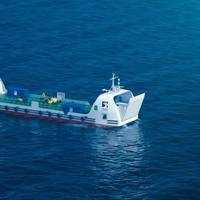
ADNOC Logistics & Services has unveiled the UAE’s first remotely operated offshore landing craft vessel, a 60-metre unmanned platform designed to improve safety, efficiency and emissions performance across offshore operations.Developed with SeaOwl and launched during Abu Dhabi Autonomous Week 2025, the vessel uses AI-enabled systems, satellite-linked controls and remote operation from ADNOC L&S’s center in Mussafah. The design eliminates onboard crew accommodation, reducing weight…
Marine News Boat of the Year: William E Moran, First in Class
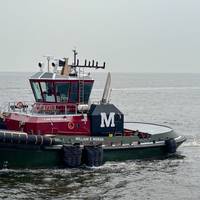
The William E. Moran has entered service in New York, bringing enhanced capability and performance to Moran’s evolving fleet. As the first vessel in the company’s next-generation class, it is purpose-built to meet the demands of modern port operations, support evolving customer needs, and advance Moran’s goals for safety, efficiency, and environmental responsibility. These next-generation tugs will be among the largest in the fleet, underscoring Moran’s continued focus on delivering safe…
Platform Allows Ships to Share Real Time Data on Navigation Hazards

Maritime technology company Orca AI has launched Co-Captain, a new function in its operational platform that allows vessels can share data with each other, in real time, to be better prepared for real-time events and emerging risks.By connecting a growing network of 1,000 Orca AI-installed vessels, with hundreds more set to join, Co-Captain turns every ship into both a sensor and source of awareness, says the company.Building on Orca AI’s advanced computer-vision technology, Co-Captain fuses these fragmented inputs into a single layer of collective intelligence.
Pole Star Global Introduces Intelligence Ecosystem with Generative AI

Maritime intelligence company Pole Star Global has launched three new products — Meridia, Meridia IQ, and Insights Data Products — forming a unified ecosystem that integrates maritime analytics, generative AI, and data delivery.Together, these solutions empower shipping companies, governments, and financial institutions to act on trusted intelligence in real time — improving safety, compliance, and operational performance across global maritime domains, says Pole Star Global.Meridia: A maritime analytics platform that consolidates port, zone, and vessel analytics into one environment.
AST Networks Unveils MODULA Connectivity Solution

AST Networks, satellite and remote connectivity specialists, have announced the launch of MODULA, a flexible and fully scalable modular approach to hybrid connectivity, designed to give maritime, offshore, and remote land-based customers the ability to tailor their connectivity to current requirements. MODULA is built on a modular architecture which mixes and matches the best of LEO, GEO, and Cellular communication networks into a single, fully managed service. MODULA allows customers to assemble their own blend of connectivity…
Maritime Firms Launch PntGuard to Counter GPS Spoofing Surge
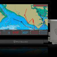
Tschudi Shipping Company, NAL Research and Norway-based SGM Technology have launched PntGuard, a maritime navigation system designed to detect and counter increasing cases of GNSS and GPS signal spoofing at sea.The standalone bridge system alerts crews the moment a vessel’s official position is falsified and provides authenticated location data when satellite navigation inputs are compromised.Developers say the product aims to address the growing risk of electronic interference and manipulation of ship positions…
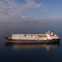
Sanctioned Russian LNG Tanker Makes STS Transfer Off Malaysia

A sanctioned liquefied natural gas (LNG) tanker made a ship-to-ship (STS) transfer off the coast of Malaysia after picking up a cargo from a Russian export terminal also under Western restrictions, according to two analytics firms.The operation appears to be the first known STS transfer of sanctioned Russian LNG, despite Western efforts to curb Moscow's energy revenues over its war in Ukraine.The LNG tanker Perle, which was sanctioned by the United States in January, had been…
Iridium Unveils Global GPS Device Protection on a Chip

Iridium Communications Inc., a provider of global voice, data, and PNT satellite communications, unveiled a miniature application-specific integrated circuit (ASIC), the Iridium PNT ASIC. Engineered for integration into a wide range of electronic devices, the Iridium PNT ASIC will deliver authenticated, pole-to-pole positioning, navigation, and timing (PNT) data. It will provide a resilient alternative to traditional GNSS, offering protection against spoofing and jamming for consumer…
Report: Mexican Bootleg Fuel and Money Laundering Cartel has Global Reach

On the afternoon of March 8, a petroleum tanker named Torm Agnes entered the Port of Ensenada on Mexico’s Pacific coast carrying almost 120,000 barrels of diesel.Such a vessel was a rare sight in that port, which mainly hosts cruise liners, luxury yachts and container ships. Ensenada lacks the infrastructure needed to unload cargos of flammable hydrocarbons safely – making what happened later that day odder still.Waves of fuel-hauling trucks rolled up to the dock to cart away much of the Torm Agnes’ load.
Intellian Launches two Iridium Certus GMDSS Systems

Satellite communication solution providers Intellian Technologies and Iridium Communications have launched Intellian’s new Iridium Certus® GMDSS Systems.The Global Maritime Distress and Safety System (GMDSS) is an internationally mandated safety system established by the IMO. It is estimated that over 80,000 vessels worldwide are required to be GMDSS compliant.Designed to fully leverage the power of Iridium Certus GMDSS, Intellian’s C200 and C700M GMDSS systems provide global coverage for vessels…
Crew Connectivity Evolves from Luxury to Lifeline

The maritime industry has long wrestled with the challenge of attracting and retaining skilled seafarers. But according to Eric Griffin, VP of Offshore Energy & Fishing, Maritime, at Inmarsat, one factor now sits firmly at the center of the conversation: seamless connectivity.On October 22, Maritime Reporter & Engineering News will host a webinar entilted Crewed Up or Crew Cut? Rethinking retention and recruitment at sea. Click here to register and to learn from vessel owners their own experience in utilizing connectivity for seafarer recruitment and retention.“Traditionally…
Next-gen Tugboat William E Moran Enters Service
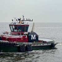
The William E Moran, the first vessel in Moran's next-generation class, recently entered service in New York. Purpose-built, the next-gen tugs will be among the largest in the Moran fleet.Built by Master Boat Builders in Coden, Alabama and designed by Robert Allan Ltd., the William E Moran belongs to the RApport 2800 series. This modern ASD Tractor tug is engineered for high-performance escort and ship assist operations. Measuring 92 feet in length with a 40-foot beam, the vessel delivers over 80 metric tons of bollard pull.
Maryland Pilots Get High-Speed Launch from Gladding-Hearn Shipbuilding
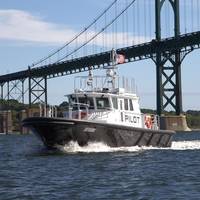
The Association of Maryland Pilots has taken delivery of its fifth Chesapeake Class launch from Gladding-Hearn Shipbuilding, Duclos Corporation since 2002. “The Maryland Pilots have some unique features and configuration control is essential to be sure their operators can seamlessly operate all the boats in their fleet. However, this must be balanced with new equipment and design updates, as well as, in some cases, retrofitting their existing boats. To make this happen over the span of 20 plus years requires a very high level of detail in the design and its execution…
New Technique Can Protect Images from AI

A new technique developed by Australian researchers could stop unauthorised artificial intelligence (AI) systems learning from photos, artwork and other image-based content.Developed by CSIRO, Australia’s national science agency, in partnership with the Cyber Security Cooperative Research Centre (CSCRC) and the University of Chicago, the method subtly alters content to make it unreadable to AI models while remaining unchanged to the human eye.Defence organizations could shield…
SFL Missions Inc. Awarded Contract for Nanosatellite Development for Norwegian Maritime Monitoring System

The Norwegian Space Agency (NOSA) has awarded a contract to SFL Missions Inc. to develop the AISSat-4 maritime ship tracking microsatellite for launch in less than one year. AISSat-4 is needed to expand operational capacity in Norway’s maritime situational awareness network.AISSat-4 is being developed on SFL’s SPARTAN 6U nanosatellite platform and will carry a single payload—a miniaturized Automatic Identification System (AIS) receiver built by Kongsberg Seatex of Trondheim, Norway.
Shipping's Tschudi Group Makes Anti-Spoofing Investment

Global maritime shipping faces a surge in GPS and GNSS disruptions — with some regions reporting a 350% increase in affected vessels over the past six months — raising concerns over safety, trade reliability, and security.In response, Tschudi Shipping Company has partnered with U.S.-based Assured Positioning, Navigation, and Timing (APNT) specialist NAL Research and Norwegian maritime technology provider SGM Technology AS to deliver a new resilient navigation and tracking solution…