New Microsatellite Boosts Norwegian Maritime Monitoring
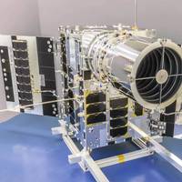
Canada’s Space Flight Laboratory (SFL) has launched Norway’s NorSat-4 maritime monitoring microsatellite.The seventh spacecraft developed for the Norwegian Space Agency (NOSA) by SFL, NorSat-4 carries a fifth-generation Automatic Identification System (AIS) ship tracking receiver and a first-of-its-kind low-light imaging camera.Built on SFL’s 35-kg DEFIANT microsatellite bus, NorSat-4 launched from Vandenberg Space Force Base in California aboard the SpaceX Transporter-12 rideshare…
Spire Wins Canadian Government Contract for Ship Tracking Data

Spire Global, a provider of space-based data, analytics and space services, announced it has been awarded a CA $1.41 million contract by the Government of Canada for the provision of global automatic identification system (AIS) ship tracking data.The one-year contract includes options for two additional years, extending the total potential contract value to nearly CA $4.23 million, Spire said.Under the contract, Spire will share its real-time global ship tracking data, providing visibility in both open oceans and high-traffic zones.
EMSA Taps Spire to Continue SAT-AIS Data Services

Spire Global, Inc., a provider of space-based data, analytics and space services, reports it has been awarded two framework contracts by the European Maritime Safety Agency (EMSA) with a maximum overall budget of €8.4 million. Concurrent with the framework award, Spire received two specific awards that total multi-million euros under the framework contracts. Under the contracts, Spire will provide space-based automatic identification system (SAT-AIS) data services for ship tracking over a four-year period, including real-time, standard and high-density backup SAT-AIS.
ASGARD: Developing an Anti-Spoofing Weapon

Saab and GMV are collaborating in ASGARD, an EU-funded project that aims to improve maritime security when using GNSS and OSNMA. The project addresses the growing threat of GNSS spoofing and other cyberattacks on navigation systems used in the maritime industry.The ASGARD project, run by Saab and GMV, is an ambitious European Union (EU) initiative that aims to develop advanced technologies to improve Global Navigation Satellite System (GNSS) and Open Service Navigation Message Authentication (OSNMA) security in maritime environments.
Tidalis Deploys New VTS at Port of Tyne

On July 1 the Port of Tyne launched a 'next-generation' Vessel Traffic Services (VTS) system to enhance VTS operator situational awareness and supports decision making.The system adheres to the standards set by the International Association of Marine Aids to Navigation and Lighthouse Authorities (IALA), covers the waters of the Port of Tyne in the UK, extending from six nautical miles out at sea to three nautical miles inland. It uses the Automatic Identification System (AIS)…
Fishing Vessel Facing $41,000 Fine for AIS Violation

A commercial fishing vessel is facing a potential $41,093 fine after allegedly violating automated identification system (AIS) regulations near the mouth of the Columbia River Dec. 3, 202, the U.S. Coast Guard said.The U.S. Coast Guard said it is pursuing a civil penalty against a commercial fishing vessel after its Sector Columbia River detected the vessel deactivate its AIS while underway near the mouth of the Columbia River in violation of 33 Code of Federal Regulations 164.46(d)(2).The captain declined to accept the Notice of Violation, issued for $5,000.
Orbcomm Wins Two U.S. Gov't Agency Contracts for Ship Tracking Services

Orbcomm Inc., a global provider of Internet of Things (IoT) solutions, has been awarded a multi-year contract by a U.S. government agency for a competitive renewal of its global Automatic Identification System (AIS) data services used for ship tracking and other maritime navigational and safety efforts. In addition, Orbcomm was awarded a separate competitive contract to deliver AIS services to multiple other U.S. government users.Orbcomm's AIS data will continue to be used in a maritime domain awareness software platform that supports key U.S.
exactEarth to Provide AIS Services for MDA's Dark Vessel Detection Program

exactEarth Ltd. has signed an agreement with MDA to provide advanced Satellite-AIS data services as part of MDA's recently announced Dark Vessel Detection (DVD) program for the Government of Canada. The DVD program is intended to detect and identify vessels that have switched off their AIS transponders and are engaged in illegal, unreported and unregulated (IUU) fishing.IUU fishing is a global problem that results in significant economic loss—estimated at $23 billion per year…
MarineTraffic Extends Partnership with ORBCOMM
Ship tracking and maritime information service MarineTraffic has extended its contract through the end of 2023 for ORBCOMM’s satellite Automatic Identification System (AIS) data.MarineTraffic, which has been an ORBCOMM partner since 2013, uses ORBCOMM’s satellite AIS data to track real-time and historical movements of ships as well as their arrivals and departures in harbors and ports around the world. MarineTraffic combines ORBCOMM’s AIS data with positional data from its network of land-based receiving stations to provide actionable maritime intelligence solutions and improve the maritime ecosystem. In addition, MarineTraffic will explore ORBCOMM’s other monitoring solutions as part of efforts to expand its offering.Greg Flessate…
Panama to Fine Ships up to $10,000 if They Tamper with Transponders
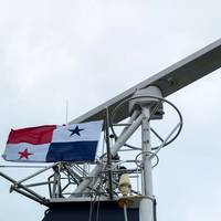
Panama's Maritime Authority said it will impose sanctions on vessels, including fines of up to $10,000 and withdrawing its flag from the ship, if they deliberately deactivate, tamper or alter the operation of their tracking transponders."This General Directorate of Merchant Marine will impose sanctions to all those Panamanian flagged vessels that deliberately deactivate, tamper or alter the operation of Long Range Identification and Tracking System or the Automatic Identification System…
USCG Issues AIS Safety Warning Following Towboat Collision
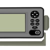
The U.S. Coast Guard has issued a safety alert highlighting the importance of accurate Automatic Identification System (AIS) data entry and display to safe navigation following a recent towboat collision on the Mississippi River.Although the investigation into this casualty is not yet complete, the Coast Guard said the incident shows the hazards created by inaccurate AIS data and should prompt owners and operators to review and update their procedures to prevent similar casualties from occurring.Before sunrise, two towing vessels were approaching a bend on the Mississippi River.
AIS Provide Skidmarks on the Ocean
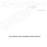
Many years ago, I received a call from an attorney who wanted me to get on the plane to Houston right away to take a look at damage on two ships that had collided in the approaches to Houston.He told me that both vessels had become confused, had started to turn and managed to occupy the same bit of ocean at the same time. His preliminary analysis indicated that, if he could prove the other vessel turned first, his vessel was in the clear.This was in the late eighties or early nineties, the course recorders had not been running, there was no VDR, and no electronic navigation record.
AIS Data: History & Future
The Automatic Identification System (AIS) was developed with the sole goal of improving maritime safety by allowing ships in proximity to one another to automatically exchange information regarding their name, course, speed, type, cargo, etc. The exchange of this information would allow conning officers on each ship to make better decisions regarding the possibility of close encounters and the need to change course and/or speed. It would also make it easier for one ship to contact the other by radio-telephone to hopefully remove any doubt. To that extent, AIS has largely worked as intended, although collisions continue to occur.It did not take long, though, for governments to get involved.


