JRC Says Its Wave Analysis Tool Helps Prevent Container Spills
Thousands of containers have been lost by ships in heavy weather conditions over recent months, impacting the ocean environment and adding a large extra cost expense for shipping companies.
Among many factors leading to the problem is heavy rolling and pitching of the ship that causes containers to lose their stability and fall overboard.
Marine electronics company JRC said its navigational radar JMR-7200/9200 includes a Wave Analysis function made available through a software upgrade.
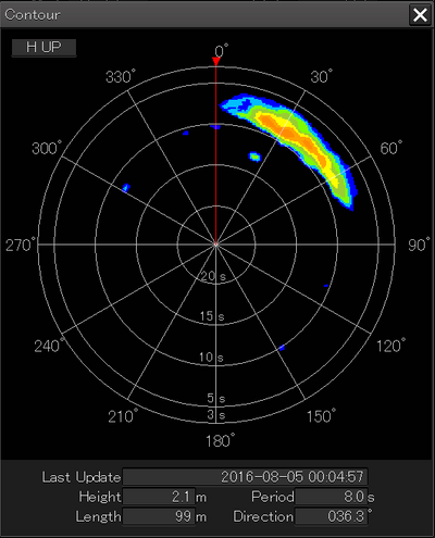
The JRC Radar Wave Analysis function is developed to measure wave height, direction and length. Even in rough seas, clearly presented wave information provides navigational officers proper decision support to steer the ship on the best course and speed to reduce rolling and pitching.
The analysis technique is developed in the radar signal processor, TM Blizzard, that realizes accurate wave measurement and ships detection simultaneously in optimizing scan correlation and pulse length adjustment. In fact, the radar can analyze the wave in a zone of 4 square kilometers ahead in the range of 1.5-2 nautical miles, while the radar’s ships detection is kept with 12 nautical miles.
In combination with a JRC Dynamic Sensor JLR-21 which can measure the motion of the vessel around three axis, a clear Conning page can be created with all motion and wave information to support the crew to make course and speed decisions in difficult sailing circumstances.
The wave analysis function is integrated in the JRC JMR-7200 and 9200 IMO radar as a software license function, no additional hardware is needed.
Due to the unique signal processing of JRC radars, ASIC tm Blizzard, the wave measurement function can be in use while important navigation radar functions are being continued up to a 12 nautical miles range for the prevention of collision with other ships.
A window within the IMO radar screen gives a clear indication of the wave height, length, period and direction in values, but also in a spectrum chart for easy and fast interpretation.
When the J-Marine box is connected, the wave data can be recorded and shared with the shore office, ship design institutes and weather data companies for research and improvement of calculation models.


