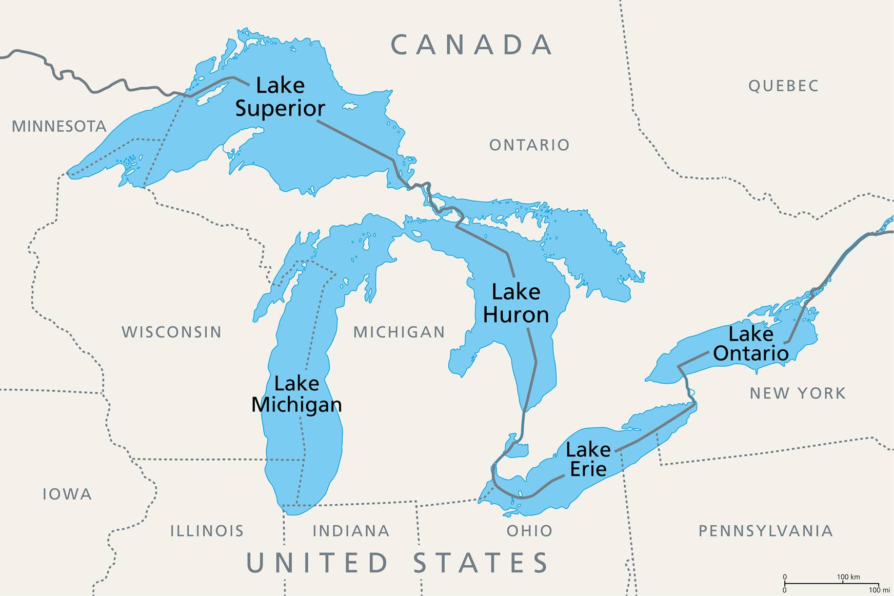
Great Lakes Water Levels Currently Below Average

The Great Lakes Water Levels Boards of the International Joint Commission have provided an updated summary of current water level conditions.
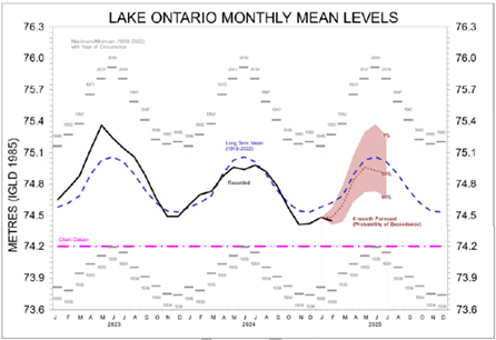
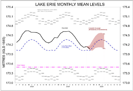
Water supply conditions throughout much of 2024 resulted in near average water levels throughout the Great Lakes and one of the longest periods of sustained near long-term average water levels on Lake Ontario.
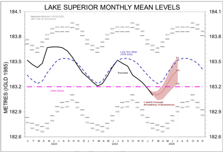
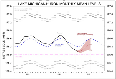
Although water levels throughout the Great Lakes continued their natural, gradual seasonal decline in fall, drought conditions in certain regions of the Great Lakes accelerated the water level decline in some of the lakes. Water levels in each of the Great Lakes, except for Lake Erie, are currently below long-term monthly averages. As of the beginning of February, and for this time of year, Lake Superior is the lowest it has been since 2013, Lakes Huron-Michigan are the lowest since 2014, and Lake Ontario is the lowest since 2003. Lake Erie levels are the lowest since 2014, although they remain approximately 1 centimeter (0 inches) above long-term average.
Ice, Drought, and Snow Water Equivalent
As of February 24, 2025, Great Lakes ice cover is 32%. Due to an Arctic blast in January, Lake Erie ice coverage increased from 30% to more than 80% over four days and is currently greater than 90% ice covered. This much ice has not been seen in Lake Erie in three years.
According to the Canadian Drought Monitor, the Canadian portion of the Great Lakes region is abnormally to moderately dry and the drought conditions are expected to be eliminated next month.
According to the U.S. Drought Monitor, 40 percent of the U.S. portion of the Great Lakes region is abnormally dry, 27% is in a moderate drought, and 4% is in a severe drought for this time of year.
According to the U.S. Drought Monitor, the February through April outlook for the Great Lakes shows the lower Great Lakes are not expected to be in a drought and will have normal soil conditions, and the upper Great Lakes are expected to come out of the current drought conditions.
The snow water equivalent within the Canadian and United States basin is approximately 6-10 cm (2-4 in). The correlation between the snow water equivalent in the Great Lakes basin and subsequent spring and summer water levels is very low. Many other factors affect the spring runoff and are difficult to estimate or predict, including how frozen the ground is when the snow melts, the moisture content of the soil, how fast the snow melts, and most crucial is how much it rains as the snow is melting and afterwards, which can increase runoff dramatically. Actual spring and summer water levels will depend primarily on weather and water supplies during the spring and summer months.
Regulation Plans 2012 and 2014, and the Lake Erie-Niagara River Ice Boom
The International Lake Superior Board of Control is responsible for implementing Regulation Plan 2012 which governs outflows from Lake Superior into Lake Michigan-Huron at the Compensating Works in the St. Marys River. Lake Superior outflows are restricted in winter to reduce the risk of ice jams that could cause flooding in the lower St. Marys River. However, the winter maximum that sometimes limits flows to 2,410 cms (85,108 cfs) is not a factor this winter.
Plan-prescribed flows are relatively low ranging from 1,690 to 1,900 cms (59,682 to 67,098 cfs) because of below-average water levels driven by dry supplies in recent months. Additionally, the balancing principle is applying a slight reduction to plan-prescribed flows (based on pre-project conditions) given the water levels in Lake Superior and Lake Michigan-Huron with respect to their long-term averages. As a result, there was no need to restrict flows to manage ice conditions - ice conditions typically prevent movement of the gates at the Compensating Works in winter.
The International Lake Ontario-St. Lawrence River Board is responsible for implementing Regulation Plan 2014 which governs outflows from Lake Ontario through the St. Lawrence River at the Moses-Saunders Hydropower Dam located at Cornwall, Ontario and Massena, NY in the St. Lawrence River. When necessary, Lake Ontario outflows are operationally adjusted in accordance with the Plan 2014 I Limit, to promote the formation and stability of ice covers in the St. Lawrence River.
The purpose of the plans is not to keep water levels at their average, which is impossible. Water levels will fluctuate with varying weather-driven water supply conditions. Regulation Plans 2012 and 2014 influence outflows. The Plan prescribed outflows are based on current water level conditions and natural water supply, governed by precipitation, evaporation, and runoff. The regulation plans were not written, and do not have the capability, to fully control or eliminate flood or drought conditions.
One of the International Niagara Board of Control’s responsibilities is to oversee the installation and removal of the Lake Erie-Niagara River ice boom. Each winter since 1964, the Lake Erie-Niagara River Ice Boom has been installed near the outlet of Lake Erie to reduce the amount of ice entering the Niagara River. A reduction in ice entering the river reduces the potential for ice jams, which can result in damage to shoreline property and significantly reduce water flow for hydroelectric power production.
The ice boom installation was completed on December 19, 2024 and will remain in place until spring 2025. High winds during the last week of January damaged parts of the ice boom, which are currently locked in place by ice. Disturbing them would push additional ice down the Niagara River; therefore, the boom will be repaired when conditions are favorable.