Keeping European Shipping on the Straight & Narrow
The European Maritime Safety Agency (EMSA) explains its role in support of marine safety, pollution, maritime security & vessel monitoring in a new brochure.
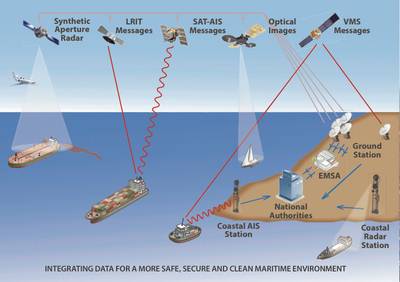
EMSA operates maritime information systems to support the maritime monitoring activities of the Commission and Member States. These systems are able to:
• monitor ship positions and movements
• exchange additional vessel information
• detect oil pollution and vessels through satellite images.
EMSA operates the European oil spill and vessel detection service CleanSeaNet. This service analyses satellite radar images to detect possible oil spills on the sea surface. Oil spills appear as dark shapes on the image. When a spill is detected, EMSA sends an alert to coastal State authorities. Analysed images are available within 30 minutes of the satellite passing overhead. The coastal authority then decides how to follow up, e.g. send an aircraft to check the spill and intercept the polluter, or to clean up the spill. If a vessel detected in an image is a suspected polluter, its identity can be checked using vessel traffic information. Optical satellite images can also be used to detect vessels. These images are now part of EMSA’s portfolio and can be delivered through CleanSeaNet.
Member States and EMSA operate SafeSeaNet, the vessel traffic monitoring and information system covering the waters in and around Europe. It acts as a platform for maritime data exchange, linking together maritime authorities from across the continent. It works by tracking Automatic Identification System (AIS) radio signals transmitted by ships. These provide identity details, latest positions and other status information in near-real-time for around 17,000 vessels operating in and around EU waters.
One of the main users of SafeSeaNet is the THETIS system. THETIS supports Port State Control inspections. It indicates which ships have priority for inspection and allows results to be recorded and shared. Information on ship arrivals and departures from ports in SafeSeaNet enables inspections to be planned efficiently.
The EMSA brochure in .pdf format is available here.


