Dredging Expected During Desperate Times
Maintaining a nine-foot channel on the Mississippi River is part of the U.S. Army Corps of Engineers Rock Island District’s critical navigation mission, especially during low-water conditions. Although early spring snowmelt caused flooding throughout the upper Midwest this past year, water levels receded quickly, causing large amounts of material to settle in the channel.
To aid in channel maintenance, geological surveyors regularly monitor water levels throughout the District. They use state-of-the-art imaging equipment to measure depths and create topographic maps of the surface beneath the water. These maps show how much sediment is settling on the riverbed and where dredging needs to be conducted.
Material that settles into the navigation channel must be removed to maintain a safe and reliable path for commercial vessels on the river.
“Dredging is expected every year, most generally in the same spots too,” said Bob Lohmeyer, Crane Operator Supervisor.
Although the placement can be predicable, the type of sediment often changes. Sometimes it is very heavy and dense while other times it’s porous and lighter. This can create challenges, either way.
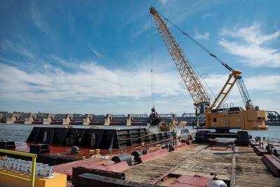
For smaller dredging needs, the District deploys a local maintenance crew from the Mississippi River Project Office in Pleasant Valley, Iowa, to perform mechanical dredging with a three-yard crane bucket mounted on a barge. The crane scoops the sediment from the bottom of the river and loads it onto another barge which then takes it to a designated areas along the river for placement, in accordance with environmental regulations.
“On a good day, we are able to fill five barges,” said Lohmeyer.
It can take days or weeks to clear a shallowed area of the river, depending on how far the barges must travel to off-load material and other working conditions on the water.


