Northern Sea Route's First Challenger
Dutch explorer Willem Barentsz wanted to find the Northern Sea Route, failed, but came back with first map of the Barents Sea
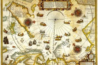
Little is known about the life of the Dutch explorer Willem Barentsz. However, his three journeys to the ocean which we today know as the Barents Sea, is well described. The most important reason for his fame is the unique map which was produced after these three voyages on the quest for the Northern Sea Route, a map that is in the possession of Cato Schiøtz, a Norwegian Supreme Court lawyer and partner in one of Norway’s largest law firms.
As the Barents Cooperation is celebrating its first 20 years, The Norwegian Barents Secretariat plans to focus on various aspects of the Barents Cooperation. The natural thing was to invite Cato Schiøtz to a seminar to tell about the man who gave name to the ocean the region is named after, informs the 'Barents Observer'.
The map was published in 1598 with an impressive amount of details. It is a sign of its quality that Norwegian explorer Fridtjof Nansen also studied the map before going on his expeditions in the Barents Sea 300 years later, says Schiøtz. Others travelled to the Barents Sea, but the Dutch made Willem Barentsz map which printed his name into this region’s history for eternity.


