Fight Piracy – Intelligently


Technology and Experience Go Hand in Hand
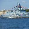
While global piracy is constantly changing, modern technology adapts to exploit the weaknesses in the pirates’ mode of operation. Intelligence gained from such technologies enables voyage planners and navigators to steer clear of harm – but what kind of information is required? While the image of the Somalian pirate is still high in the public’s mind as the number one piracy threat, the reality is not as straightforward.
Pirates have had to change their tactics in the last few years, with a geographical expansion to the oil-rich Gulf of Guinea, including the waters off Nigeria, Ivory Coast, Ghana, Benin, Togo, Cameroon and Lagos. However, pirates are not shy of extending their roaming to Angola and Congo and seizing opportunities arising from political instability in Syria, Egypt and Libya. Beyond these areas, from India and Indonesia to Peru and the Philippines, piracy is still a threat.
This geographical expansion is just one reaction to the presence of the Navy task forces around the Gulf of Aden. Another is their use of “mother ships” operating from calm and open sea areas such as in the South Atlantic. Beyond this, pirates no longer limit themselves to hostage taking and ransom demands, expanding their repertoire to stealing high-value cargo from oil or gas tankers. Offshore installations, around Nigeria for instance, have also become an attractive target, as have support vessels. Many platforms and small vessels used for crew transfer remain unprotected and can be easy prey.
Intelligence – the Premium Piracy Countermeasure
While piracy has evolved, so too have its countermeasures. In addition to armed guards and navy protection, which are still an effective deterrent, e-Navigation solutions can provide valuable information to help seafarers avoid an encounter.
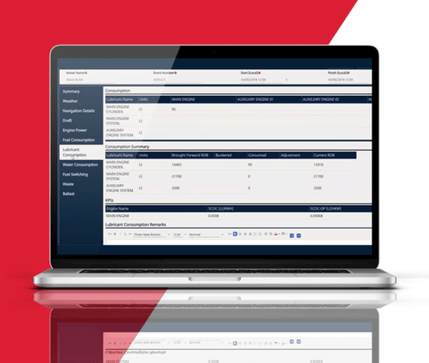
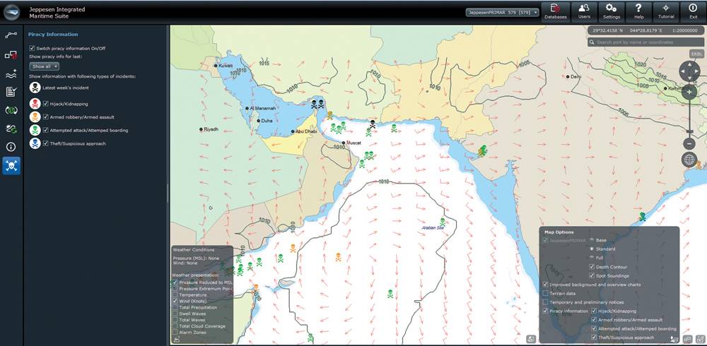
This is well proven by Jeppesen’s PiracyUpdate, an electronic chart overlay available for ECS and ECDIS that helps identify, understand and manage the risks associated with crime at sea. Based on intelligence from recognized and authoritative sources on global sea piracy, it is used by mariners, shipowners and operators, insurers and several national navies to reduce the likelihood of vessel attacks. As pirates rely on certain sea states to operate, weather information is an essential element of anti-piracy data. Jeppesen OceanView is a marine planning software combining navigational charts, weather information and automatic route planning to create a more comprehensive picture for decision support in high risk areas.
That said, it is important to keep in mind that like with any good thing, too much data can bring along complications in the shape of information overload. Feedback from the PiracyUpdate and OceanView customers helped Jeppesen to optimize and streamline the voyage planning process within free-to-use NauticalManager software, which aggregates both weather and piracy data into a lean and user-friendly interface.
The Benefits of Advanced Intelligence Tools
As a second officer aboard an offshore PSV/tug vessel, I was charged by my captain and towmaster to do voyage planning for the tow of a jack-up rig from Amenam field in Nigeria to Ghana. At the time, we had no electronic planning means. Except for an ECS, planning had to be done on paper charts. I had to take into account the latest intelligence report shared verbally by the towing master and look for certain weather and wave patterns. The weather forecasts came in the shape of Internet printouts. During the planning, there were sudden indications that piracy activities were extending beyond the “safe offshore distance.” This meant that I had to re-plan the whole voyage, and the entire process ended up taking two days.
Today, with a tool like Jeppesen NauticalManager, ship’s staff can incorporate daily piracy activity notices with up-to-date weather information. In OceanView, “alarm limits” for weather conditions (wave height, for example) can be set. This would reduce the time required to create a complete voyage plan from two days down to 20 minutes, and adapting to new circumstances would take minutes instead of hours. The integration of electronic nautical charts with information such as weather and piracy and e-Navigation software yields significant benefits for the mariner. It not only optimizes voyage safety and fuel efficiency, but also streamlines the entire voyage planning process.
OceanView and PiracyUpdate in Action
OceanView in conjunction with PiracyUpdate has widely been used to identify high-risk areas and obtain up-to-date information on the latest piracy activity. This includes keeping track of hijacked ships and the involvement of pirate mother ships. During a hijacking of a Greek oil tanker off the Ivory Coast, Jeppesen’s partner Bergen Risk Solutions (BRS) used a digital anti-piracy tool to provide vital insight to lawyers, insurers, the owner, charterers and other parties involved.
In this case, a vessel carrying 14 hijackers armed with AK-47 assault rifles and knives approached the 73,400-dwt oil tanker, which was in the process of carrying out two ship-to-ship transfers off Abidjan with 30,000 tons of gas oil on board. Before the second operation took place, the vessel displayed suspicious behavior. At approximately 0100 hours local time, it switched off all lights and sailed directly south without explanation. BRS used PiracyUpdate to compare this suspected hijacking with similar incidents and was able to inform the client on what had happened, the risk to the crew, vessel and cargo, as well as on what was likely to happen next.
BRS was tasked to coordinate the logistics involved in preparing the eventual release of the hostages and the vessel. This usually includes helicopter transfer, possible medical evacuation, liaising with the protection and indemnity (P&I) insurance holder of the vessel and more. At this point, however, when and where the release would have taken place was unknown.
BRS started plotting the tanker’s movement. Based on their experience and incident reports in OceanView, they soon realized the vessel was heading for a known piracy stronghold in Nigeria. This information was parsed among the parties involved in the rescue such as navies and rescue services so they could converge on the location of the hijacked tanker.
When the pirates realized their plans had been compromised, they accepted to release the hostages and the vessel in exchange for amnesty. Soon afterwards, the necessary resources could be routed to the tanker to take care of both the crew and the vessel. It was a relief for everyone that the crew left the ordeal unscathed.
(As published in the August 2014 edition of Maritime Reporter & Engineering News - http://magazines.marinelink.com/Magazines/MaritimeReporter)